Smith Lake
Smith Lake Gold Project
RENABIE, ONTARIO
Property Overview
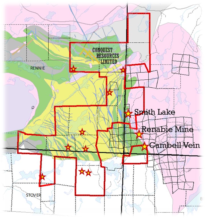
- The Smith Lake Gold Property consists of a 100% interest in 6 patented claims and 181 staked mining claims covering approximately 29 square kilometers of land
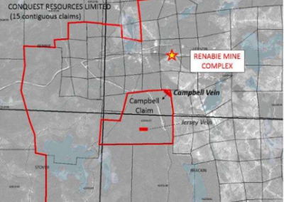
- The property is located between the former Renabie Mine to the east of the Manitou Gold / Alamos land package to the west, is 100% Conquest owned and is contiguous with the former International Corona Resources (now Barrick Gold Corporation) Renabie Mine which produced more than 1,000,000 ounces of gold from 1941 through 1991.
- Access to the Property is via former logging and mine-access roads leading North from the terminus of Highway-651 located two kilometres east of Missinabie, ON.
Deposit Potential
- Our property is adjacent to the former international Corona Resources Renabie Gold Mine. Mine production at Renabie totalled approx. 1.1M ounces of gold at an average grade of 6.6 grams of gold per tonne and 2 grams of silver per tonne.
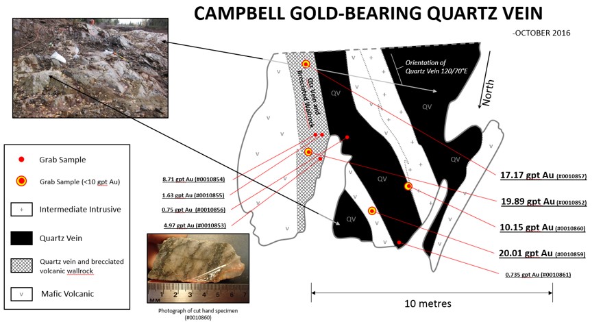
- The Campbell Claim is the only staked claim that is not contiguous with the rest of the Smith Lake Property. That being said, the claim is underlain by mixed volcanic and intrusive assemblages that are host to the Campbell Vein. Preliminary exploration work has identified significant grab sample results; 4 of the 10 grab samples returned between 10 and 20 grams of gold per tonne, another 4 of these samples exceeded 1 gram per tonne of gold.
- There are a total of thirty mineral occurrence in the immediate area of the Smith Lake Gold Property. Thirteen of these occurrences lie within Conquest’s claim group. fake tag heuer link


Geology
- The geology of the Missanabie area is characterized by a series of Late Archean and Precambrian aged mafic metavolcanic rocks of the Michipicoten Greenstone Belt located in the Wawa Subprovince which isloosely known locally as the east Wawa gold camp.
- Intrusive porphyritic stocks and sills cross-cut this belt, and associated granitic gneisses surround the Michipicoten greenstone belt on all sides. Aeromagnetic maps of the region define the general position and trend of the metasedimentary-volcanic belts and distinguish them clearly from felsic plutons.
- The Renabie Gold Mine is located within the Missinaibi Lake batholith and lies immediately south and east of Conquest’s Smith Lake Property. This intrusive complex (Missinaibi Lake batholith) is U/Pb dated at 2,720.8±1.4 Ma. Mafic to felsic metavolcanic flows and pyroclastic units dominate the western portion of the Smith Lake area.
- Faulting in the area occurs as two distinct sets. One of the fault-set trends east-northeast across the area and the other fault-set trends north to north-northwest; both trends are defined by topographic lows, and evidence of shear deformation zones that are observed in outcrop.
- Campbell Claim
- The property is underlain by metavolcanic rocks. The dominant rock type consists of green, fine to medium grained massive to locally pillowed mafic metavolcanics.
- The metavolcanics trend 350 degrees and are crosscut by diabase dykes that are orientated north-northwest, subparallel to the metavolcanic and TTG rocks of the Wawa Domal Complex. Local pink quartz-feldspar porphyritic units are present across the claim. Dark green to black fine-grained diabase dykes also crosscut the property.
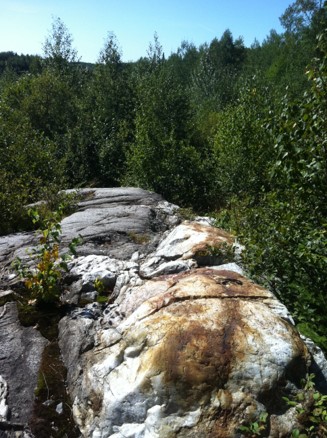
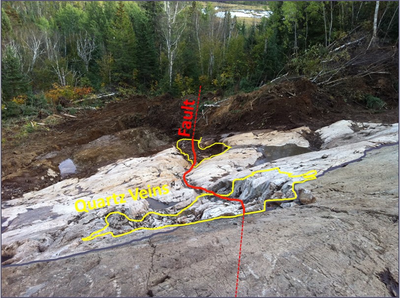
- Small, thin quartz veins are common in outcrop across the Smith Lake Property. The quartz veins cross cut the metavolcanics. Two significant veins are present on the Campbell Claim. There are two known significant veins present on the Campbell Claim: (1) the Campbell Vein and (2) the newly discovered Jersey Vein.
Exploration on the Smith Lake Gold Project
- During the 1980’s, a predecessor company to Conquest Resources Limited named Conquest Yellowknife Resources Limited (“CYRL”) owned nearly 150 square kilometres in the Missanabie-Goudreau greenstone belt. The focus of the exploration efforts during the 1980s were centred on CYRL’s six patented mining claims comprising property and regional surface mapping, VLF geophysics, local soil geochemistry, and surface exploration drilling.
- In 2004, Conquest completed a geological mapping program in combination with a soils survey on the Company’s patented mining claims.
- 2011:
- Exploration drilling totaled 1,109 metres in ten holes which were drilled on the Smith Lake patented claims.
- A total of 318 samples were collected from the core, 30 samples returned anomalous assays ranging from 0.25g/t to 63.3 g/t over 0.22 to 1.50 metres in core length thickness.
- 2012:
- Conquest completed a winter-spring drill program at Smith Lake comprising a total of 2,652 metres of exploration drilling in twenty-three holes designed to target east-west and north-south oriented structures near the northern extension of the north-south oriented Braminco Shear Zone, at sites with coincident structural and Mobile Metal Ion (“MMI”) surface geochemical anomalies on Conquest’s patented claim group.
- The most significant assays of the 2012 portion of this program include a 0.22 metre interval grading 17.53 g/t gold in hole CSL-12-003, and a 1.19 metre interval grading 16.48 g/t in hole CSL-12-018.
- Furthermore, the government of Ontario released a geophysical data set containing a compilation of local and regional airborne magnetic and electro-magnetic geophysical data for the area covering 70% of the new amalgamated Conquest land package in the Renabie area.
- 2013:
- Conquest contracted Fugro Airborne Surveys to conduct a GEOTEM airborne electromagnetic and magnetic survey of the Renabie area designed to expand on the 2012 database released by the Government of Ontario (See below).
- Conquest’s EM survey specifically targeted the delineation of structural and stratigraphic features used to explore for volcanogenic massive sulphide (“VMS”) base metals and structurally hosted gold deposits. A total of 175 line-kilometres of magnetic and electromagnetic data was collected and interpreted in this survey.
- 2015:
- Exploration work during 2015 included; prospecting, rock and soil sampling, geochemistry, and rock description, followed by a desktop structural lineament analysis and interpretation. The most anomalous assay values occurred in two rock grab samples that returned values of 0.26 g/t and 0.24 g/t gold. Three soil samples yielded highly anomalous values for gold: 200 ppb, 180 ppb, and 120 ppb gold
- An interpretation of surface lineaments identified twenty-five east-west oriented structures on the Smith Lake property which are parallel in orientation to the mineralized zones at Renabie and Nudalama. East-west lineaments are of principle interest to Conquest for gold exploration on the Smith Lake property, especially given that all but one of the identified lineaments are associated with GEOTEM target sites.
- Furthermore, anomalous samples collected over two of these lineament areas have both coincident rock and soil anomalies, as well as geophysical anomalies.
- 2016:
- Conquest carried out an overburden stripping program to expose the gold-bearing Campbell vein located immediately south of the main shaft at the Renabie mine on Conquest’s property. Four of the ten grab samples exceeded 10 g/t gold from the Campbell Vein. Another four of these samples exceeded 1 g/t gold. All samples collected were anomalous.
- 2021
- Consultation with both the Missanabie Cree and the Michipicoten First Nation has been undertaken. An associated Exploration Permit is currently under review and the Company is awaiting final approvals before commencing its planned exploration program.
- Given growing concerns with respect to containing the spread of COVID-19, many indigenous communities have declared a state of emergency or taken other measure to protect community health and safety that may disrupt normal field exploration and /or aboriginal consultation and engagement activities.
Future Exploration Work
- Conquest’s goal on the Smith Lake Gold Property and surrounding area is to discover another gold deposit similar in size to Renabie in addition to exploration for volcanogenic massive sulphide mineralization within the metavolcanic successions present in the Missanabie-Goudreau greenstone belt.
- Additional exploration is warranted over the east-west trending lineament areas and areas of geophysical interest from Conquest’s airborne EM survey. A property-wide summer exploration program would comprise prospecting, mapping, overburden stripping and sampling.
- Prospecting and detailed field investigation of the entire 106 hectare-sized Campbell Claim should be undertaken. Associated work should include rock and soil sampling, as well as mapping to describe outcrops and quartz/mineralized occurrences with a focus on structural geology to potentially identify diamond drill targets for gold mineralization.
- Soil geochemistry on a cut grid should be carried out over the entirety of the Campbell Claim. Soil collected over the Campbell Vein displayed highly anomalous gold chemistry which is considered significant and supports the development of a trace element geochemistry program over the property.
- A ground magnetic survey should be completed over the proposed cut grid. Selected areas suspected to have strong potential for mineralization may have structural affinities discernable by modern inversion techniques not previously available for past exploration.
Reports
2016 Campbell Claim Stripping Program – Smith Lake Property
2013 Airborne Geophysical Survey – Smith Lake Property
