Lake Nipigon
Lake Nipigon Basin Project
Lake Nipigon, Ontario

Property Overview
- The Lake Nipigon Basin Property is located south of Black Sturgeon Lake in Nipigon, Ontario.
- Situated in the Lake Nipigon Basin (“LNB”), the property is highly prospective for uranium mineralization associated with veins and faults and PGE-Ni-Cu deposits at or near the Archean-Proterozoic unconformity south of the Black Sturgeon Lake in the LNB.
Deposit Potential
- As exemplified in the Athabasca Basin, unconformity related Uranium deposits are all associated with faults and fracture systems proximal to the regional unconformity.
- The Sibley Group of continental sedimentary rocks have been identified above the unconformity with the pre-Cambrian basement in the Lake Nipigon area. Uraniferous veins of the unconformity type are found at the Split Rapids Dam and Canyon occurrences, both located to the north of the Property.
- Historical intersections at Split Rapids Dam range from 0.012% U3O8 over a core length of 0.30 m in drill hole BS05-13, to 2.99% U3O8 over a core length of 1.5 m in drill hole BS05-30.
- Other occurrences, such as Greenwich Lake occur regionally, resemble the Athabasca unconformity type and have the best potential for the presence of uranium deposits.
Geology
- In the Lake Nipigon Basin, the most probable source area for uranium deposits associated with veins and faults that are proximal to the Proterozoic/Archean unconformity is the granitoid and associated meta-sedimentary rocks of the Quetico Gneiss Belt (Figure 1).
- The Quetico Gneiss Belt’s signature is one of anomalously high uranium background levels, as identified from Ontario Geological Survey (Scott,1987), highlighting the similarities of the Athabasca basin and the Sibley Basin geological and structural histories.
- Early Proterozoic rift related mafic and ultramafic intrusive rocks are prospective for PGE-Ni-Cu deposits in the Lake Nipigon region as exemplified by the many occurrences or deposits discovered ie. Seagull, Disreali, and more recently, Thunder Bay North and Sunday Lake.
- Conquest believes the continental basement rocks have been subjected to intense regional faulting related to extensional basin style deformation or rifting southwest of Lake Nipigon, possibly representing a part of the Nipigon Rift system itself and consequently revealing a large extensional rift below the unconformity.
Exploration on the Lake Nipigon Basin Project:
2000-2001:
- In 2000-2001, 31 magnetotelluric (MT) data sites were collected across a regional northwest to southeast mapped fault system, south of Black Sturgeon Lake, and within the Nipigon project area.
- These data have recently been reprocessed and used to generate an estimate of the resistivity distribution below the profile of sites. The interpreted results are shown in Figure 1. The 31 MT site positions along the west to east profile are plotted above the color contoured resistivity estimate.
- Within the top 0-500m depth a low resistivity layered geologic sequence has been interpreted, reflecting a combination of Sibley sediment horizons are variably intruded by the high resistivity Nipigon diabase sills on/in the near surface layer, as observed in outcropping geology.
- Below 500m to greater than 2000m the resistivity increases significantly on the west and eastern parts of the profile (interpreted as resistive basement) while a large central region, 3-4 km wide, indicates lower resistivity rocks continuing to depth.
- Conquest interprets this to be a probable area of basin extension and/or intensive north to south fracturing/deformation on a multi-kilometre scale that may be permissive for the presence of a variety of deposit types including fault and unconformity related uranium veins and PGE-Ni-Cu bearing Proterozoic mafic and ultramafic intrusions.
- Building on the Athabasca Uranium exploration and early Proterozoic rift related PGE-Ni-Cu deposits exploration models, Conquest is exploring the SW Lake Nipigon region in search for economic minerals deposits of the type formed in rifted or extensional environments (Figure 2), and employing extensive use of deep-penetrating geophysical techniques including natural field magnetotellurics and ground time domain electromagnetic geophysics.
- Additional field work will include structural mapping as a thick cover of Sibley Group sediments, intruded by Nipigon sills, blankets the area.
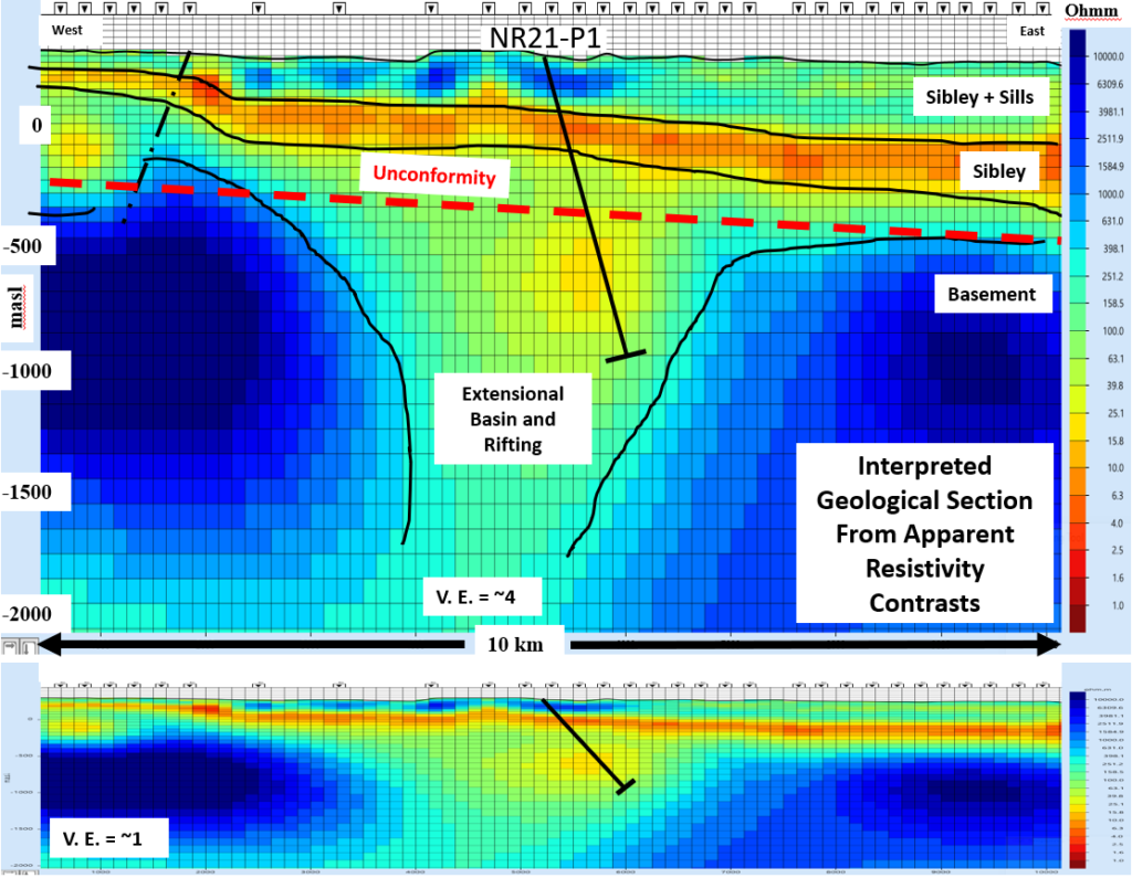
Figure 1 – Interpreted apparent resitivity section Nipigon Rift Property
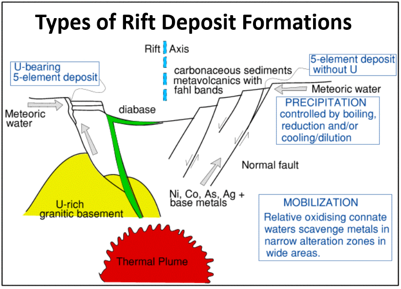
Figure 2- Vertical sections showing conceptual formation of deposit types of extensional basin/rift deposits (U, Ni-Cu-Co-PGE)
Future Exploration Work:
- Conquest intends to commence a Phase 1 drill program in the first half of 2022 aimed to confirm the presence of the Nipigon Rift on the Property.
- The program will also target a discrete, very low resistivity region just below the interpreted unconformity (Figure 1).
- Conquest recently staked an additional 351 cells on strong evidence of an interpreted north-south deformation zone.
References:
- Bowbridge, C. 2006: Report on 2005 Diamond Drilling, Black Sturgeon East Block, prepared for Rampart Ventures Ltd., New Shoshoni Ventures Ltd.
- Scott, J.F. 1987: Uranium Occurrences of the Thunder Bay-Nipigon-Marathon Area; Ontario Geological Survey, Open File Report 5634, 158p.